


How LakeMapper Works
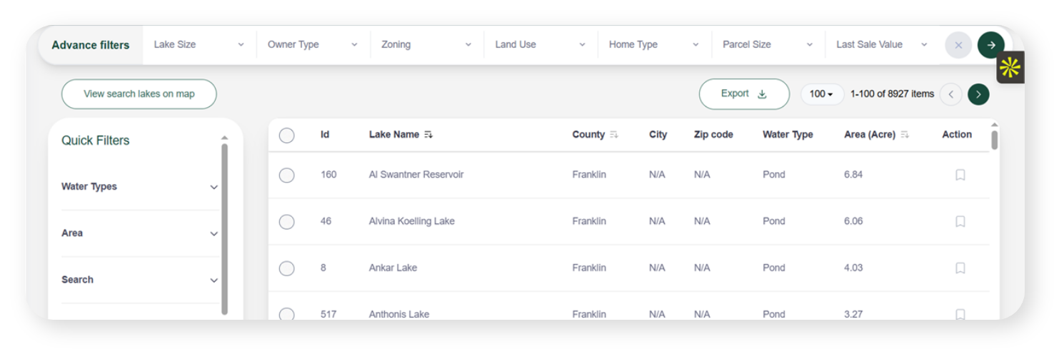
Discover Lakes and Ponds
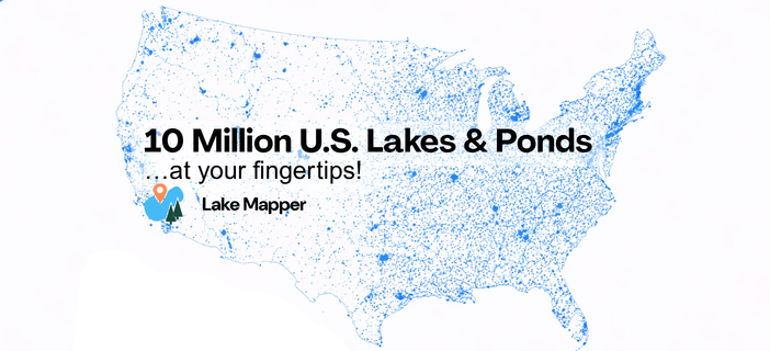
Search our comprehensive database of all U.S. ponds and lakes with precise location data and ownership details.
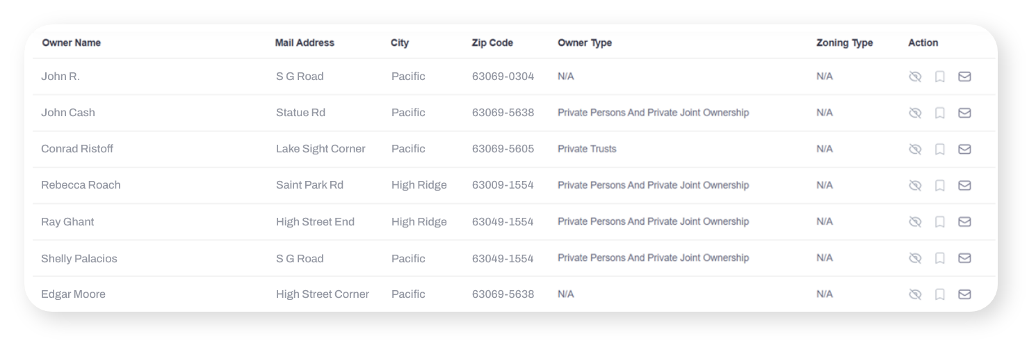
Filter Parcel List
Choose property owners and parcels surrounding your target lakes with detailed filtering and segmentation tools.
Direct Mail Center
Deploy targeted direct mail campaigns with custom designs to reach waterfront property owners instantly.
Find lake property owners and launch targeted campaigns in 3 Simple Steps.
LakeMapper
Features and Tools
LakeMapper offers robust search and selection filters to enable users to find ponds and lakes that meet their criteria. And when your favorites are found, promote your services using the LakeMapper embedded direct mail system.

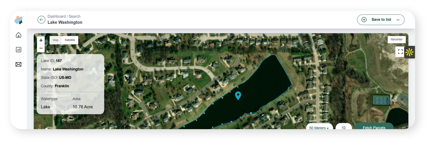
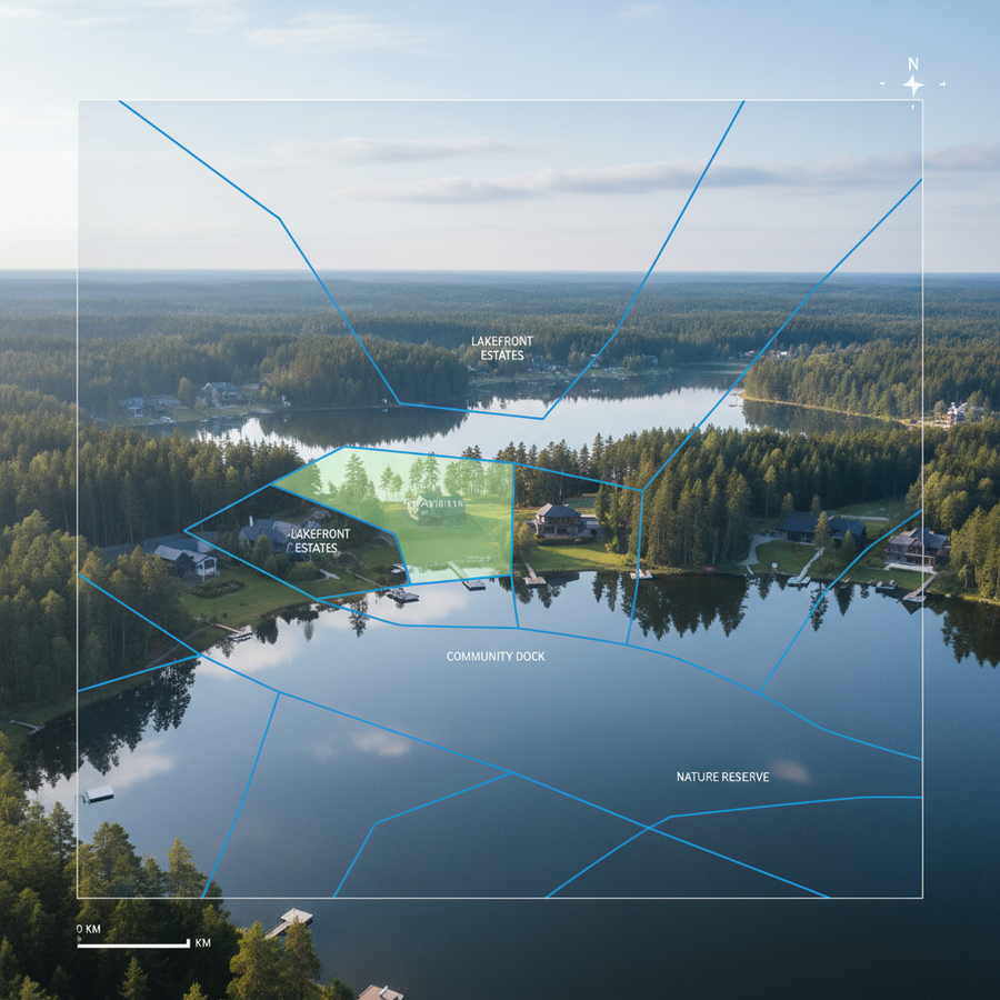
Our propriety satellite mapping system identifies waterbodies and assigns geo coordinates to the lake and its perimeter.
- Lake area is calculated in acres
- Non-lakes, such as rivers and streams, oxbows, are removed, so users only see ponds and lakes!
- Search for lakes by State, County, Zip, Address, Radius
- Water Types: Ponds, Lakes, Large Lakes and Reservoirs
- Search for single-owner and multi-owner ponds and lakes.
- Save lakes to targeted lists for each of search and outreach.
Identify and reach lake and pond property owners directly with accurate owner data pulled from public records.
- Owner name, parcel physical address, mailing address
- Owner type: private, HOA, commercial, government, etc.
- Zoning: residential, commercial, industrial, municipal, agricultural and use: residential, golf-course, multi-family, wastewater treatment, etc.
- Parcel size in acres
- Parcel value (if available)
Use our integrated direct mail system to promote your services to lake property owners in your target area.
- Send 1 to thousands of postcards or letters
- Create mailing lists by area, lake type, owner type, etc
- Postcards: small and large formats
- Letters: multiple page and envelope formats
- Brochures: bifold & trifold (minimums apply)
- QR code for response tracking
- FREE starter templates for your editing
- Custom design assistance (Review Design Survey)
- Upload your own design FREE! (Design Guide)
- Robust delivery and response

Your Reliable Source
for Lake Property Data
It uniquely identifies the owner parcels that contain or border each water body providing precise ownership and property classification data not available in standards public waterbody datasets.
Success Stories from Our Customers

LakeMapper
Pricing & Plans
Select the plan that works best for you!
Individual Starter
Access to lake data base with basic filters
Includes:
- 2 states (additional $25/month)
- 120 phone & email append credits/quarter on a monthly plan or 500 under annual
- Does not include Mail Center access
- Includes parcel For-Sale listing status
- Unlimited lake search & owner parcel discovery
- Unlimited parcel list creation
- Convenient quarterly billing
- *Overages and other charges apply. See Terms & Conditions.
Individual Pro
For users that need more efficiencies and streamlined invoicing.
Includes:
- No list rental fees with Mail Center use
- 2 states (additional $42/month)
- Mail Center Access: Postcards & Letters*
- 250 phone & email append credits/quarter on monthly plans or 1,000 on annual plans
- Unlimited lake search & owner parcel discovery
- Unlimited mailing list creation
- FREE postcard starter templates
- Quarterly billing cycle
- *Additional charges apply. See Terms & Conditions
Includes:
- Multi-state access
- Discounted Credits
- Discounted Mailing Fees
- Managed Service
- Custom Services
Latest News & Insights
Fresh articles and useful reads from our team
LakeMapper Expands to a National Footprint, Names The Last Splash to Lead Growth
Unlock More Dock Builder Leads: Your Guide to Waterfront Client Acquisition
The Algae Debate Is a Sales Opportunity. Here Is How to Use It.
Elevate Lake Management Marketing: Strategies to Find and Connect with More Lakefront Property Owners
Is There a National Database of U.S. Lakes and Ponds?
Find Lake Properties for Sale Near Me

LakeMapper: The Easiest Way to Find and Engage Lake Property Owners
Help Center
Everything you need to make the most of LakeMapper. Get support, report issues, manage your account, or access tutorials and documentation.


Report Issues
Experiencing technical difficulties with the platform? Report it here.

Account and Billing
Questions about your subscription, pricing, or payment?

Resource Materials
Access step-by-step tutorials on lake search, parcel filtering, mail campaigns.
LakeMapper FAQs
LakeMapper is extremely accurate. In fact, we had to create algorithms to remove swimming pools, rivers, streams, oxbows and other waterbodies with which most of our subscriber would not have an interest. In the case where LakeMapper has erroneously labeled a non-waterbody as a lake (flooded low area), the subscriber can flag the lake to be permanently removed.
LakeMapper was built for lake management professionals & suppliers, real estate professionals, landscapers, property & managers and land developers. Examples include professionals and companies that provide aquatic weed control services, fountains and aeration equipment, fishery and fish stocking services, dock builders/suppliers, dam maintenance, and realtors seeking properties that meet lake
buyer criteria.
LakeMapper uses a propriety process of identifying lakes based on satellite images, calculate their location, perimeter and area in acres. From there we associate the land owner parcels that contain or surround the lake, along with their publicly available attributes, including owner name and address info, parcel zoning and use attributes, parcel size and value date, if available. A secondary process allows subscribers to reverse append and email addresses associated with the parcel data. Reverse append data, where available, is not guaranteed for accuracy and stems from a 3 rd party.
Postcard and letter templates are 100% customizable. The LakeMapper system includes several free templates which can be edited to the sender’s liking – replacing images, copy, contact info, logos, etc. Plus, users can work with LakeMapper to create a fully customized template specifically for their business, or upload a template created by a 3 rd party, as long as it meets our printing requirements found here.